Your Guide to Hiking (and Trail Markers) in Israel
- Kobi Tour Guide of Israel

- Aug 5, 2020
- 4 min read
So you have been on a hike in Israel and saw a bunch of trail markers and wanted to know what they meant. Or you plan on hiking in Israel and want to get prepared. Either way, this post is for you.
But first, a little history. 2600 years ago, after the Babylonians had destroyed Jerusalem and taken many of the Judeans to captivity in Babylon ["by the Rivers of Babylon"], they placed someone in charge of Judea before they left - a man named Gedaliah. A Jew who was not happy with the Babylonians placing someone who was not of the line of King David in charge [the Davidic dynasty had ruled for the past 400 years] assassinated Gedaliah and the rabbis instituted a fast day to commemorate this tragedy (it conveniently falls right after Rosh Hashana during which we gorge ourselves for two days). Jeremiah, the prophet at the time, led remnants of the people fearful of a Babylon retribution [for killing their appointed ruler] down to Egypt. As stated in Jeremiah 31:21, he told them to "set up signposts, keep in mind the road that you traveled; return maiden Israel, return to these towns of yours." This may be the first trail markers in history, predating Hansel & Gretel, Lewis & Clark and the Portland Trailblazers by over two millennia.
In addition to apparently having set up the first trail markers in history, modern Israel today has more marked hiking trails per square mile/km than any other country in the world. The Israel National Trail is a 680 mile (1100km) trail which covers the country from north to south and was named by National Geographic as one of the 20 best hiking trails in the world due to the incredible diversity of the landscapes, it's access to historical and cultural sites and the amazing trail angels who take in travelers along the way.
Ze'ev Vilnai, the founding father tour guide of Israel, once wrote the following:
"I believe that there is no better way to feel the connection to the Land of Israel than to walk across its length and breadth. To cross the valleys, climb its mountain peaks, exploring its paths - even the most forsaken ones. So, when you're touring on foot across the country, taking pleasure in the landscapes and seeing with your own eyes the remains of the ancient and the new settlements, you feel a real connection to the Land of Israel and become a son/daughter of this land."
So what do all the various trail marker signs mean? Let's get to it....


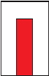
These trail markers (on right) appear along the path of trails which are up to 10km (6.2 miles) long. They are in green, blue, black and red, though the colors have no significance apart from helping to delineate between various trails.


Same trails as above but when it is horizontal, it marks the start of the trail.


These are for regional trails from 60-100km (37-62 miles) in length. Examples are the Lower Galilee, Springs Valley, Jesus Trail, Jezreel Valley, Ramot Menashe, HaSharon, Har HaNegev and Ramon trails. They are in orange or purple.


When one of the regional trails ends up following the same path as one of the smaller local trails, an orange or purple dot will be placed at the top of the local trail marker.


Two specific regional trails have their own special trail markers. The white-blue-green trail on the left is the Golan Trail, whereas the white-purple-blue trail on the right is the trail around the Kinneret (Sea of Galilee). On an official trail map, the Golan Trail is in blue whereas the Kinneret trail is in purple.


This is the marker of the aforementioned Israel National Trail. The orange signifies the desert, the blue signifies the seas and the white, the snow of the Hermon mountain. The marker also shows the direction one is heading. If the orange is higher, you are heading south towards the desert. If the white is higher, you are heading north towards the Hermon. On an official trail map. the Israel National Trail is in pink.


The shape of the trail marker on the left (which can be in any color) shows a turn in the trail. The shape of the markers in middle and on the right show a junction in the trail (whether a T-intersection or a 4-way intersection).

The shape of this trail marker shows the end of a trail. Again, it could be in any color, depending on the trail.


The trail marker on the right - a clear strip down the middle where a color should be - signifies a site of interest less than 150m (492 feet) off of the path, which does not appear on an official map (due to space concerns). The trail marker in the middle shows that one has arrived to the site of interest in question. The trail marker on the left shows - as an example - a clear trail leading off of a green trail.
For more on hiking the Israel National Trail - and to purchase a set of trail maps - click here: https://www.natureisrael.org/INT
I would be remiss as an Israel tour guide to not remind you to wear a hat, closed hiking shoes and sunscreen and bring plenty of water. And make sure to stay on the marked trails!
Are you ready to come hit the happy trails with me?
Don't forget to follow me on FB, Instagram and/or Twitter to get all my blog post updates:
And check out - and share - my videos on YouTube : https://www.youtube.com/channel/UCli9MpzZdJHSeiDXNFjM5QA


#tourguideofisrael #tourguideisrael #israeltourguide #israelguideisrae l#tourisrael #israeltrip #israeltours #israeltrips #privateisraelguide #israelprivateguide #privateguideofisrael #personalizedisraelexperience #tourofisrael #toursofisrael #triptoisrael #israeloutdooradventure #outdooradventureinisrael #israeladventure #adventureinisrael #extremesportsisrael #extremesportsinisrael #israelextremesports #israelextreme #extremeisrael #outdooradventureisrael #adventureisrael #walkisrael #walkingisrael #hikeisrael #hikingisrael #israelhike #israelhiking #israeltrail #israelnationaltrail

![[Almost] All Restrictions on Entering Israel Set to End](https://static.wixstatic.com/media/920376_2606b0cba5b94c51a3c2019ce39d6e45~mv2.jpg/v1/fill/w_980,h_729,al_c,q_85,usm_0.66_1.00_0.01,enc_avif,quality_auto/920376_2606b0cba5b94c51a3c2019ce39d6e45~mv2.jpg)

Comments