I Just Walked Across The Entire Country
- Kobi Tour Guide of Israel

- Jun 7, 2021
- 9 min read
I just walked across my entire country. Okay it's Israel, so it's not that big, but I can tell you that it was not easy....

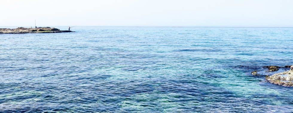
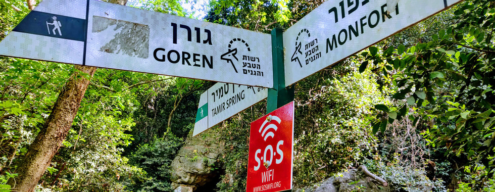
The hike is called "Yam el Yam" or "Sea to Sea" and it starts on the Mediterranean seashore and heads across the northern part of the country known as the Galilee to Lake Kinneret, also known as the Sea of Galilee. There are a few different versions of it, but the classic one begins at the Achziv Beach and goes through the Kziv Stream, Mount Meron and Amud Stream. It begins at sea level, rises to 1200m (3600 feet) above sea level to Israel's tallest pre-1967 mountain and then descends to 210m (630 feet) below sea level. It is around 85km (53 miles) and it took me about 38 hours spread out over 4 days though some serious hikers can pull it off in three.
Day 1:
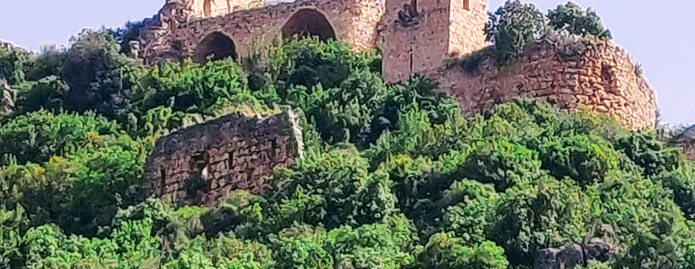
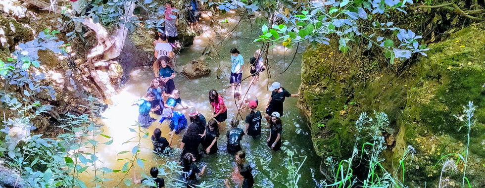
I decided to do this on my own and taking two trains and two buses from Jerusalem, made it to Achziv Beach a little before 10AM. I went down to the water where I filled up a little bit of water from the Mediterranean Sea to carry with me along the way - an old Israeli tradition - to then deposit into Lake Kinneret at the end. Just as I was about to start I reached for my hiking poles - and realized that I had left them at home. Not a good start. I found the Achziv Bridge (which the Palmach had attempted to blow up in the Night of the Bridges in 1946). The first 8km (5 miles) was flat along the coastal plain, through banana fields and avocado groves. Finally I entered into the Kziv riverbed where I found someone selling ice cream. Perfect. Clearly I had made it to the entrance to the nature reserve, in which a good number of Israelis went out for a nice dip in the cool stream. I hiked through this riverbed when finally I saw above my head the archaeological jewel of the trip: Montfort Castle. This was Crusader fortress was the administrative center of the Teutonic Knights from 1228 until its fall to the Mamluks in 1271. The last part of the day, however, was a grueling 2 hour climb up to the Amirim fortress where I would camp for the night.
You can see all today's photos here (click on the arrow on the right of the big photo):


Day 2:
I packed up and was on the road at 730AM. For those doing this hike in 3 days, this is the longest and hardest of the days. I wasn't planning on doing that, but I was keen on getting an early start anyway. The truth is that sadly, this day did not go as planned. First of all, I got lost. That being said, it was more of a misssteak than a mistake. You can see my video here about that...
The bigger issue was that I was beginning to have serious trouble with my legs. Despite stretching out repeatedly, I found myself several hours behind and by the time I got to the first water stop of the day - a gas station on Route 89 - I could barely move without immense pain. I realized that I had pushed myself too far. After a year of not being as active as I am usually, not having had my hiking poles for the big climb the day before, and having everything on my back (nobody to share the load with) - and mind you I hadn't carried a weight that heavy since the army - 25 years ago - I had clearly bitten off more than I could chew. Knowing that there was no way I was going to make the campground before dark, much less be able to physically climb the mountain the next day, I had to stop. The path went under Route 89 and I climbed up onto the overpass and grabbed a bus home.
Basically, I felt like Barney from How I Met Your Mother, when he runs the NYC Marathon without any training whatsoever and then can't actually move his legs afterwards (just YouTube "Barney Marathon" and you can watch that episode in all its glory).
Here are the photos:


I had figured I'd be back in a week to try again. I was wrong. I couldn't walk for a week; I had pulled both my calves and hamstrings so badly...
After 2 weeks (and a few massages) I was ready to go again, but unfortunately Operation Guardian of the Walls put an end to that idea. Finally, when everything quieted down I was set to go. This time, however, I had my hiking poles and even more importantly, I had an angel in my pocket. A trail angel. A good friend and fellow unemployed tour guide lived just off the next section of the trail. Not only did he take me in one of the two nights, but most importantly, he took my big bag from campsite to campsite, allowing me to be able to hike with just my daypack (full of water, lunch and a medical kit). What a difference that made! I found I could enjoy the hike and not think about how much pain my legs (and back) were in. This was definitely the way to go!
Day 2 Take 2:
I began the rest of Day 2 where I had left off a few weeks earlier - Elkosh Junction on Route 89. I quickly moved through this portion of the hike which was now part of the Mount Meron Nature Reserve. Without my big bag I moved quickly. About an hour in I started to feel a bit sore but I managed to push through and within four hours that afternoon I had made it to the Hurvat Hamama campsite (a "hurva" is a ruined site). Along the way I had seen a beautiful spring, olive trees and a surprise rest stop (see the video below).
And here are the photos from this section of the trail:


Day 3:
I started this day with virtually no energy. I had the misfortune of having three large groups at the campsite with separate agendas. One school wanted to sing and shout by the campfire until 230AM, another school woke everyone up with 50 air horn blasts from 5-6AM and then there was the IDF which had a ceremony and training. I had no idea how long I was going to be able to this day before collapsing. In the end, I managed to somehow pull off around 30km (18 miles).
The hike began with a climb up Mount Meron to the peak trail. Right at the beginning I saw the familiar blue-white-orange trail marker of the Israel National Trail. I would join onto this trail almost to the end of Yam-el-Yam (Sea-to-Sea). Along the way I would meet some 20 small groups of post-army youth who had started the Israel National Trail - one of National Geographic's Top 20 long-distance trails worldwide - in Eilat back in late March. It was wonderful to see them doing this trek. We joked that they were doing "tzfona v'negba" and I was doing "yama v'kedma." If you are unfamiliar with that terminology, there is a song called Ufaratzta, which is the words from Genesis Chapter 28 Verse 14. God tells Abraham to go out to the north (tzfona), south (negba - literally towards the Negev desert), west (yama - to the sea - i.e. the Mediterranean) and to the east (kedma - to where you were originally).

At the top of Mount Meron not only did I get to see an ancient wine press, but there were incredible views all around, including into Lebanon (hence the army base) and most importantly, I could see the glimmer of the Sea of Galilee below - my end point. I could see the end.
Continuing on I saw grape vines and fig trees, a memorial to the firefighters who died in the Carmel Fire a few years back set up by a Druze family who had lost a loved one in that disaster, a cave which was a natural home for doves, a spring which was a home for fire salamanders, a rock formation known as "Elijah's Chair," the tomb of Rabbi Shimon Bar Yochai on Meron - the site of a more recent disaster - and what possibly the tomb of Rabbi Shammai (of the great Hillel-Shammai debates). All that was before I ever got to the jewel of the day - Amud Stream.
One could easily be forgiven for thinking they had landed in Sherwood Forest when walking along Upper Nachal Amud. For several hours I walked through a beautiful forest canopy with a stream and pools below my feet. Schoolchildren splished and splashed in the pools, notably at the Sekhvi pools which tooks its name from the Arabic name for the site - al-Jaj, which means grouse. Apparently in addition to the dozens of ancient mills in the area there were also wild chickens running around at one point.
The last part of the day was Middle Nachal Amud, which like day 1 left the hardest for last. Once I got past the sign for the path up to En Koves (about an hour later) it got tough! I don't have pictures because I needed my hands for the handlebars, ladders and to be firmly on my polls to keep my balance on the cliff edges. This part is clearly for experienced hikers only - with hiking polls - and not for children. Finally after three hours I reached the end of this section and the campground. I had hiked for almost 12 hours. Desperately needing sleep at this point, my trail angel not only brought me my stuff, but took me home to sleep in a real bed. With only 12km (7 miles) left to go, I let myself sleep in.
Here are the photos:


Day 4:
I came back to the trail at noon. It was the hottest part of the day but it was a short hike comparatively. I walked along a white-rock riverbed and a strange structure by Israel's Mekorot water company which resembled some ancient ziggurat or temple, a carob tree and incredible cliffs until I finally reached the amud or pillar for which the stream is named (Nachal Amud). There a yeshiva was splashing around in a seasonal spring. I decided to push on to the lake.
A small surprise along the way was to see the Golgolet Cave where the earliest human skull ever found int eh Land of Israel was discovered. At some point Tiberias came into view along with Arbel cliffs and finally the lake itself. I crossed a melon patch and more banana groves until I reached Route 90 - Israel's longest north-south road which goes from Eilat to Metulla. At this point I deviated from the trail. I climbed up on to the road and walked an extra 15-20 minutes south in order to get to the much better beach at Kibbutz Ginosar. There among the pomelo trees, date palms and a eucalyptus grove I finally made it to the water. I poured my bottle of Mediterranean Sea water into the lake (see video), stretched out my muscles on the grass, changed into my swimsuit and jumped into the lake. I had made it. I had walked across the entire land of Israel from sea to sea, yama v'kedma.
Photos from the last day:


Summary:
I had done Nachal Kziv, the Mount Meron summit hike and Upper Nachal Amud before but never the entire thing put together. Truth be told, these were the prettiest - and most popular - part of the hike. Still there was something incredible about walking the breadth of the land and I definitely felt an incredible sense of accomplishment (even if I had that unfortunate pause in the middle). I would not do this entire thing with kids, though there were a few fathers and sons (and one father and a daughter) who were doing this as a Bar/Bat Mitzvah bonding moment, whom I met on the way (the kids were experienced hikers). Definitely pack light (or have someone move your bags) and make sure you have hiking poles and carry 5-6 liters of water each day and fill up at the various points. There are also places to stay nearby that one can hike to off the trail if one would prefer not to carry a tent/sleeping bag/etc. and would like nicer accommodation (and a good night's sleep). A phone with external chargers is key so that you can follow along some of the various Israeli navigational apps, such as Amud Anan (like Waze for hikers), which is especially useful on the second day. And don't forget that small water bottle so that you can bring the water, from sea to sea.
Don't forget to follow me on FB, Instagram and/or Twitter to get all my blog post updates:
And check out - and share - my videos on YouTube : https://www.youtube.com/channel/UCli9MpzZdJHSeiDXNFjM5QA
#tourguideofisrael #tourguideisrael #israeltourguide #israelguide #israeltour #israeltrip #israeltours #israeltrips #privateisraelguide #israelprivateguide #privateguideofisrael #israeladventure #personalizedisraelexperience #tourisrael #tourofisrael #toursofisrael #triptoisrael #israel #israelitourguide #israeliprivateguide #privateisraeliguide #privateisraelitourguide #walkisrael #israelculinarytour #israeltechtour #israelartsandculture #israeliartsandculture #artsandcultureofisrael #israelartsandculturetour #israeliartsandculturetour #israelartsandculturetours #israeliartsandculturetours #toursofisraelsartsandculture #israeloutdooradventure #outdooradventureinisrael #israeladventure #adventureinisrael #extremesportsisrael #extremesportsinisrael #israelextremesports #israelextreme #israeloutdoors #extremeisrael #outdooradventureisrael #adventureisrael #walkingisrael #hikeisrael #hikingisrael #israelhike #israelhiking #israeltrail

![[Almost] All Restrictions on Entering Israel Set to End](https://static.wixstatic.com/media/920376_2606b0cba5b94c51a3c2019ce39d6e45~mv2.jpg/v1/fill/w_980,h_729,al_c,q_85,usm_0.66_1.00_0.01,enc_avif,quality_auto/920376_2606b0cba5b94c51a3c2019ce39d6e45~mv2.jpg)

Comments